IMAGES TAKEN NEAR TO
Houndhill Park, Bolton Road, ROTHERHAM, S63 7LG
Introduction
This page details the photographs taken nearby to Houndhill Park, Bolton Road, S63 7LG by members of the Geograph project.
The Geograph project started in 2005 with the aim of publishing, organising and preserving representative images for every square kilometre of Great Britain, Ireland and the Isle of Man.

There are currently over 7.5m images from over14,400 individuals and you can help contribute to the project by visiting https://www.geograph.org.uk
Image Map
Images are licensed for reuse under creativecommons.org/licenses/by-sa/2.0
Notes
- Clicking on the map will re-center to the selected point.
- The higher the marker number, the further away the image location is from the centre of the postcode.
Image Listing (12 Images Found)
Images are licensed for reuse under creativecommons.org/licenses/by-sa/2.0
Image
Details
Distance
1
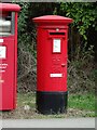
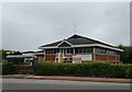
Elizabeth II postbox on Manvers Road
Postbox No. S63 474.
Image: © JThomas
Taken: 19 Sep 2022
0.19 miles
2
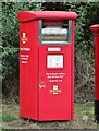
Royal Mail parcel / business box on Manvers Road
Postbox No. S63 475.
Image: © JThomas
Taken: 19 Sep 2022
0.19 miles
3
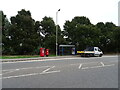
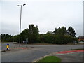
Manvers Road
Showing position of Postbox No. S63 474 and Postbox No. S63 475.
Image: © JThomas
Taken: 19 Sep 2022
0.19 miles
4
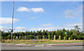
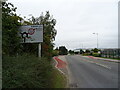
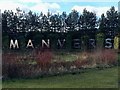
Manvers sign.
Manvers is perhaps the biggest reclaimed brown field site in Europe. Once the home of chemical works, collieries and rail it now houses call centres, offices and huge warehouses.
Image: © Steve Fareham
Taken: 5 Sep 2007
0.21 miles
7
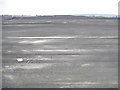
Brookfield Park, Manvers
This area was covered by mine workings and railway sidings, all of which have now gone. It is one of the largest redevelopment projects in the country.
The site has been levelled and industrial units are now being erected.
Image: © Christopher Thomas
Taken: 13 Oct 2005
0.22 miles
9
Manvers industrial estate sign
Once the area was surrounded by coal, rail and chemical industries.
Image: © Steve Fareham
Taken: 15 Feb 2016
0.23 miles