IMAGES TAKEN NEAR TO
Denman Road, ROTHERHAM, S63 6SP
Introduction
This page details the photographs taken nearby to Denman Road, S63 6SP by members of the Geograph project.
The Geograph project started in 2005 with the aim of publishing, organising and preserving representative images for every square kilometre of Great Britain, Ireland and the Isle of Man.

There are currently over 7.5m images from over14,400 individuals and you can help contribute to the project by visiting https://www.geograph.org.uk
Image Map
Images are licensed for reuse under creativecommons.org/licenses/by-sa/2.0
Notes
- Clicking on the map will re-center to the selected point.
- The higher the marker number, the further away the image location is from the centre of the postcode.
Image Listing (6 Images Found)
Images are licensed for reuse under creativecommons.org/licenses/by-sa/2.0
Image
Details
Distance
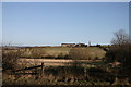
2
Newhill Grange, Wath-upon-Dearne
Newhill Grange is group of recent barn conversions overlooking open countryside.
Image: © Christopher Thomas
Taken: 25 Sep 2005
0.16 miles
3
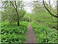
Woodland path beside Brook Dike
Looking south-westward.
Image: © Peter Wood
Taken: 4 May 2018
0.20 miles
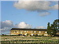
4
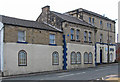
father's house church
A Pentecostal church in West Melton
Image: © Graham Hogg
Taken: 2 Sep 2024
0.23 miles
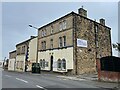
5
West Melton - Father's House
On High Street.
Image: © Dave Bevis
Taken: 3 Aug 2013
0.23 miles
