IMAGES TAKEN NEAR TO
Blake Avenue, ROTHERHAM, S63 6NT
Introduction
This page details the photographs taken nearby to Blake Avenue, S63 6NT by members of the Geograph project.
The Geograph project started in 2005 with the aim of publishing, organising and preserving representative images for every square kilometre of Great Britain, Ireland and the Isle of Man.

There are currently over 7.5m images from over14,400 individuals and you can help contribute to the project by visiting https://www.geograph.org.uk
Image Map
Images are licensed for reuse under creativecommons.org/licenses/by-sa/2.0
Notes
- Clicking on the map will re-center to the selected point.
- The higher the marker number, the further away the image location is from the centre of the postcode.
Image Listing (18 Images Found)
Images are licensed for reuse under creativecommons.org/licenses/by-sa/2.0
Image
Details
Distance
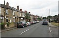
1
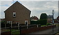
Houses on Coleridge Road
Taken from Christchurch Road.
Image: © Ian S
Taken: 31 May 2014
0.07 miles
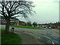
5
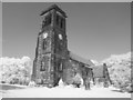
Brampton Bierlow Church
Christ Church Brampton Bierlow
Image: © stephen gascoigne
Taken: 22 Apr 2011
0.20 miles
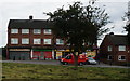
9
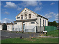
West Melton - Welcome Mission
On Winterwell Road.
Image: © Dave Bevis
Taken: 3 Aug 2013
0.21 miles
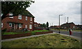
10

Burns Way
1950s council houses in West Melton.
Image: © Burgess Von Thunen
Taken: 27 Feb 2013
0.21 miles