IMAGES TAKEN NEAR TO
Hoober, ROTHERHAM, S63 6HD
Introduction
This page details the photographs taken nearby to Hoober, S63 6HD by members of the Geograph project.
The Geograph project started in 2005 with the aim of publishing, organising and preserving representative images for every square kilometre of Great Britain, Ireland and the Isle of Man.

There are currently over 7.5m images from over14,400 individuals and you can help contribute to the project by visiting https://www.geograph.org.uk
Image Map
Images are licensed for reuse under creativecommons.org/licenses/by-sa/2.0
Notes
- Clicking on the map will re-center to the selected point.
- The higher the marker number, the further away the image location is from the centre of the postcode.
Image Listing (13 Images Found)
Images are licensed for reuse under creativecommons.org/licenses/by-sa/2.0
Image
Details
Distance
3

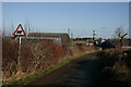
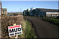
Hoober Hall Lane
Approaching Hoober Hall Farm.
Image: © JThomas
Taken: 27 Sep 2014
0.02 miles
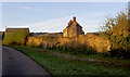
8
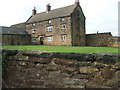
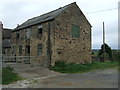
Hoober Hall
This 17th century farmhouse, built sometime between 1600-1632, is part of a working farm.
Image: © George Middleton
Taken: 19 Oct 2005
0.10 miles