IMAGES TAKEN NEAR TO
Shirewood Close, ROTHERHAM, S63 6BT
Introduction
This page details the photographs taken nearby to Shirewood Close, S63 6BT by members of the Geograph project.
The Geograph project started in 2005 with the aim of publishing, organising and preserving representative images for every square kilometre of Great Britain, Ireland and the Isle of Man.

There are currently over 7.5m images from over14,400 individuals and you can help contribute to the project by visiting https://www.geograph.org.uk
Image Map (Loading...)


Getting Data...Please wait
Leaflet Map data © OpenStreetMap
Images are licensed for reuse under creativecommons.org/licenses/by-sa/2.0
Notes
- Clicking on the map will re-center to the selected point.
- The higher the marker number, the further away the image location is from the centre of the postcode.
Image Listing (35 Images Found)
Images are licensed for reuse under creativecommons.org/licenses/by-sa/2.0
Image
Details
Distance
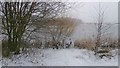
3
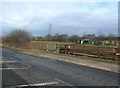
Paddock on Westfield Road
There's an electrical substation right behind the paddock which explains the profusion of pylons.
Image: © Jonathan Clitheroe
Taken: 17 Feb 2017
0.07 miles
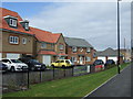
4
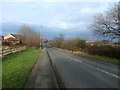
Westfield Road at Brampton Bierlow
Image: © Jonathan Clitheroe
Taken: 17 Feb 2017
0.09 miles
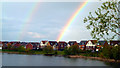
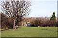
5
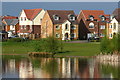
A view over the lake in Brampton Bierlow
Image: © Jeff Pearson
Taken: 2 May 2005
0.17 miles
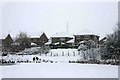
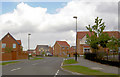
6
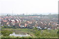
New Housing Estate from top of old Cortonwood spoil heap
View over the southern end of the new housing estate at Brampton Bierlow. Taken from the old Cortonwood Colliery spoil heap.
Image: © Jeff Pearson
Taken: 15 Apr 2007
0.19 miles