IMAGES TAKEN NEAR TO
Dearne Lane, ROTHERHAM, S63 5DE
Introduction
This page details the photographs taken nearby to Dearne Lane, S63 5DE by members of the Geograph project.
The Geograph project started in 2005 with the aim of publishing, organising and preserving representative images for every square kilometre of Great Britain, Ireland and the Isle of Man.

There are currently over 7.5m images from over14,400 individuals and you can help contribute to the project by visiting https://www.geograph.org.uk
Image Map
Images are licensed for reuse under creativecommons.org/licenses/by-sa/2.0
Notes
- Clicking on the map will re-center to the selected point.
- The higher the marker number, the further away the image location is from the centre of the postcode.
Image Listing (77 Images Found)
Images are licensed for reuse under creativecommons.org/licenses/by-sa/2.0
Image
Details
Distance
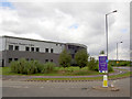
2

Entrance to Manvers.
A new area created from brown fields of mining and rail.
Image: © Steve Fareham
Taken: 17 Aug 2007
0.05 miles
3
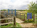
Bridge over beck into Old Moor RSPB centre.
Image: © Steve Fareham
Taken: 17 Aug 2007
0.09 miles
4

A633 Manvers road bridge over Trans Pennine Trail.
The stream is the Knoll Beck.
Image: © Steve Fareham
Taken: 17 Aug 2007
0.10 miles
5
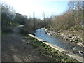
Knoll Beck
Looking upstream [locally west]. The path forms part of the Trans Pennine Trail.
Image: © Christine Johnstone
Taken: 19 Mar 2022
0.10 miles
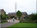
6
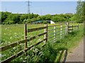
Old Moor fence
A RSPB site, in the background murals on the underpass (part of the Trans Pennine Trail) depict birds.
Image: © Steve Fareham
Taken: 22 May 2010
0.11 miles
8

Bridge over Knoll beck dominated by pylon.
On the Trans Pennine Trail.
Image: © Steve Fareham
Taken: 17 Aug 2007
0.11 miles
9
This Way to the RSPB Site at Old Moor
Image: © Terry Robinson
Taken: 31 May 2008
0.11 miles
10
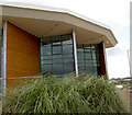
New offices under construction by MSSR.
Image: © Steve Fareham
Taken: 17 Aug 2007
0.11 miles