IMAGES TAKEN NEAR TO
Hood Hill, ROTHERHAM, S62 7UB
Introduction
This page details the photographs taken nearby to Hood Hill, S62 7UB by members of the Geograph project.
The Geograph project started in 2005 with the aim of publishing, organising and preserving representative images for every square kilometre of Great Britain, Ireland and the Isle of Man.

There are currently over 7.5m images from over14,400 individuals and you can help contribute to the project by visiting https://www.geograph.org.uk
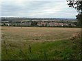
Image Map
Images are licensed for reuse under creativecommons.org/licenses/by-sa/2.0
Notes
- Clicking on the map will re-center to the selected point.
- The higher the marker number, the further away the image location is from the centre of the postcode.
Image Listing (34 Images Found)
Images are licensed for reuse under creativecommons.org/licenses/by-sa/2.0
Image
Details
Distance
2
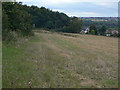
The slopes of Hood Hill
Looking north towards Barnsley.
Image: © Alan Murray-Rust
Taken: 13 Sep 2009
0.06 miles
6
View from Hood Hill
Looking over Harley towards Hoyland.
Image: © Alan Murray-Rust
Taken: 13 Sep 2009
0.13 miles
9
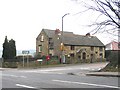
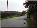
Kirkby Lane Postbox
Postbox at the intersection of the B6068 Kirkby Lane to Rotherham, with the A6135 at Hood Hill.
Image: © Roger May
Taken: 13 Mar 2006
0.15 miles
10
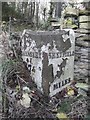
Old Milepost by the A6135, Sheffield Road, Wentworth parish
Cast iron post by the A6135, in parish of WENTWORTH (ROTHERHAM District), Sheffield Road, 45m Southwest of junction with Kirby Lane, entrance to Hood Hill Plantation, on right near Lamppost 21, almost opposite Kirby Lane, on North side of road. Erected by the Wakefield & Sheffield turnpike trust in the 19th century.
Inscription reads:-
: BARNSLEY / 7 / (MILES) : : (LONDON) / 170 : : SHEFFIELD / 7 / (MILES) :
Grade II listed.
List Entry Number: 1132767 https://historicengland.org.uk/listing/the-list/list-entry/1132767
Milestone Society National ID: YS_BNSF07.
Image: © C Minto
Taken: 16 Jul 2002
0.15 miles