IMAGES TAKEN NEAR TO
Barrowfield Lane, ROTHERHAM, S62 7TP
Introduction
This page details the photographs taken nearby to Barrowfield Lane, S62 7TP by members of the Geograph project.
The Geograph project started in 2005 with the aim of publishing, organising and preserving representative images for every square kilometre of Great Britain, Ireland and the Isle of Man.

There are currently over 7.5m images from over14,400 individuals and you can help contribute to the project by visiting https://www.geograph.org.uk
Image Map
Images are licensed for reuse under creativecommons.org/licenses/by-sa/2.0
Notes
- Clicking on the map will re-center to the selected point.
- The higher the marker number, the further away the image location is from the centre of the postcode.
Image Listing (112 Images Found)
Images are licensed for reuse under creativecommons.org/licenses/by-sa/2.0
Image
Details
Distance
1
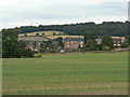
Barrowfield Gate
A summer view to complement this winter view http://www.geograph.org.uk/photo/704993.
Image: © Alan Murray-Rust
Taken: 13 Sep 2009
0.01 miles
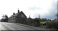
2
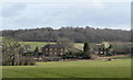
Barrowfield Gate
Looking north from Barrow to Barrowfield Gate. The house on the right used to be the police house complete with office and lock up. The building in the centre - now 3 houses - used to be a school.
Image: © Dave Archer
Taken: 24 Feb 2008
0.01 miles
3
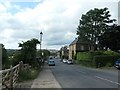
Barrow Field Gate, on Barrow Field Lane
Heading north-west from Wentworth. Barrow Field itself is just beyond the hamlet.
Image: © Christine Johnstone
Taken: 11 Aug 2019
0.01 miles
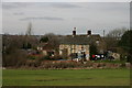
5
The pound
A pair of cottages in Barrowfield Gate with the spire of Wentworth new church in the background. The walled garden of the nearer cottage used to be the village pound, where stray animals were brought and kept until the owner paid a fine.
Image: © Dave Archer
Taken: 24 Feb 2008
0.07 miles
6
Cottages just west of Wentworth village
Image: © Jeff Pearson
Taken: 15 Mar 2009
0.09 miles
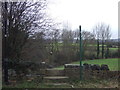
7
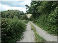
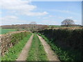
Public footpath to Low Wood and Elsecar
Heading north from Barrow Field Lane. When and why was a concrete road built here?
Image: © Christine Johnstone
Taken: 11 Aug 2019
0.10 miles
8
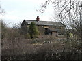
The old abattoir
Currently modified to be the premises of a woodworking company, this building was originally the estate abattoir. As viewed, the left end was the slaughterman's house and the right the abattoir, with a yard for the animals onto the lane running past that end.
Image: © Dave Archer
Taken: 24 Feb 2008
0.13 miles
10
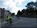
Sunday Cyclists ... turn off Main Street onto Barrow Field Lane, Wentworth, near Rotherham - 1
Elsecar here we come ...
See also ...
Image
Image: © Terry Robinson
Taken: 14 Oct 2012
0.16 miles