IMAGES TAKEN NEAR TO
Warren Vale, ROTHERHAM, S62 7SS
Introduction
This page details the photographs taken nearby to Warren Vale, S62 7SS by members of the Geograph project.
The Geograph project started in 2005 with the aim of publishing, organising and preserving representative images for every square kilometre of Great Britain, Ireland and the Isle of Man.

There are currently over 7.5m images from over14,400 individuals and you can help contribute to the project by visiting https://www.geograph.org.uk
Image Map
Images are licensed for reuse under creativecommons.org/licenses/by-sa/2.0
Notes
- Clicking on the map will re-center to the selected point.
- The higher the marker number, the further away the image location is from the centre of the postcode.
Image Listing (10 Images Found)
Images are licensed for reuse under creativecommons.org/licenses/by-sa/2.0
Image
Details
Distance
1
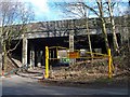
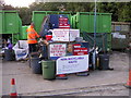
Entrance to 'Dump it' site
Bridge carries 'New' Warren Vale Road over.
Image: © Steve Fareham
Taken: 8 Mar 2008
0.02 miles
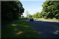
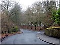
3
Warren Vale, Rawmarsh
Looking south.
Image: © Christopher Thomas
Taken: 26 Sep 2005
0.09 miles
4
Rawmarsh Tip
More correctly called Warren Vale Household Waste Recycling Centre, Rawmarsh.
Image: © Christopher Thomas
Taken: 23 Sep 2005
0.12 miles
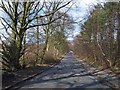
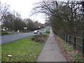
5
Old Warren Vale
The original route of the A633 which now runs straighter and to the east
Image: © Graham Hogg
Taken: 13 Mar 2018
0.14 miles
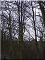
8
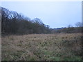
Waste ground and the edge of Dyson's Plantation
Image: © Jonathan Thacker
Taken: 19 Jan 2019
0.22 miles
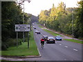
9
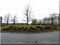
Approaching Swinton
The town's name in box hedging on a roundabout on Warren Vale
Image: © Graham Hogg
Taken: 13 Mar 2018
0.23 miles