IMAGES TAKEN NEAR TO
Hoober, ROTHERHAM, S62 7SA
Introduction
This page details the photographs taken nearby to S62 7SA by members of the Geograph project.
The Geograph project started in 2005 with the aim of publishing, organising and preserving representative images for every square kilometre of Great Britain, Ireland and the Isle of Man.

There are currently over 7.5m images from over14,400 individuals and you can help contribute to the project by visiting https://www.geograph.org.uk
Image Map
Images are licensed for reuse under creativecommons.org/licenses/by-sa/2.0
Notes
- Clicking on the map will re-center to the selected point.
- The higher the marker number, the further away the image location is from the centre of the postcode.
Image Listing (26 Images Found)
Images are licensed for reuse under creativecommons.org/licenses/by-sa/2.0
Image
Details
Distance
8
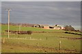
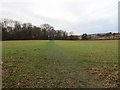
Hoober Hill
View from Street Lane to Hoober Hill
Image: © Richard Croft
Taken: 11 Dec 2007
0.13 miles
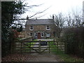
9
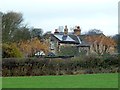
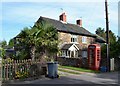
Hoober House
Hoober House, the headquarters of sales training company Huthwaite International, is tucked away privately in woodland. This was at one time a girls' finishing school.
Image: © Graham Hogg
Taken: 28 Nov 2011
0.14 miles