IMAGES TAKEN NEAR TO
Higher Stubbin, ROTHERHAM, S62 7RY
Introduction
This page details the photographs taken nearby to S62 7RY by members of the Geograph project.
The Geograph project started in 2005 with the aim of publishing, organising and preserving representative images for every square kilometre of Great Britain, Ireland and the Isle of Man.

There are currently over 7.5m images from over14,400 individuals and you can help contribute to the project by visiting https://www.geograph.org.uk
Image Map
Images are licensed for reuse under creativecommons.org/licenses/by-sa/2.0
Notes
- Clicking on the map will re-center to the selected point.
- The higher the marker number, the further away the image location is from the centre of the postcode.
Image Listing (11 Images Found)
Images are licensed for reuse under creativecommons.org/licenses/by-sa/2.0
Image
Details
Distance
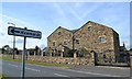
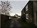
2
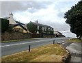
Cottages at Higher Stubbin
The ivy-clad cottage is Comrie House.
Image: © Jonathan Clitheroe
Taken: 13 Aug 2016
0.04 miles
7
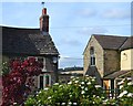
Cottages at Low Stubbin with view to Hoober Stand
Image: © Neil Theasby
Taken: 9 Oct 2012
0.18 miles
9
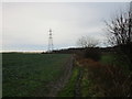
Footpath to Hoober
At that point where ice starts to turn to mud.
Image: © Jonathan Thacker
Taken: 16 Dec 2017
0.21 miles