IMAGES TAKEN NEAR TO
Trueman Drive, ROTHERHAM, S62 7FA
Introduction
This page details the photographs taken nearby to Trueman Drive, S62 7FA by members of the Geograph project.
The Geograph project started in 2005 with the aim of publishing, organising and preserving representative images for every square kilometre of Great Britain, Ireland and the Isle of Man.

There are currently over 7.5m images from over14,400 individuals and you can help contribute to the project by visiting https://www.geograph.org.uk
Image Map
Images are licensed for reuse under creativecommons.org/licenses/by-sa/2.0
Notes
- Clicking on the map will re-center to the selected point.
- The higher the marker number, the further away the image location is from the centre of the postcode.
Image Listing (14 Images Found)
Images are licensed for reuse under creativecommons.org/licenses/by-sa/2.0
Image
Details
Distance
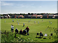
1
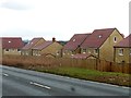
New houses on Wentworth Road
The development is called 'The Wickets', taking this name from the Upper Haugh Cricket Club whose ground is nearby.
Image: © Graham Hogg
Taken: 13 Mar 2018
0.02 miles
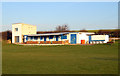

10

The Marquis
Large pub and carvery restaurant on Stubbin Road
Image: © Graham Hogg
Taken: 13 Mar 2018
0.17 miles