IMAGES TAKEN NEAR TO
Newbiggin Close, ROTHERHAM, S62 6NN
Introduction
This page details the photographs taken nearby to Newbiggin Close, S62 6NN by members of the Geograph project.
The Geograph project started in 2005 with the aim of publishing, organising and preserving representative images for every square kilometre of Great Britain, Ireland and the Isle of Man.

There are currently over 7.5m images from over14,400 individuals and you can help contribute to the project by visiting https://www.geograph.org.uk
Image Map
Images are licensed for reuse under creativecommons.org/licenses/by-sa/2.0
Notes
- Clicking on the map will re-center to the selected point.
- The higher the marker number, the further away the image location is from the centre of the postcode.
Image Listing (40 Images Found)
Images are licensed for reuse under creativecommons.org/licenses/by-sa/2.0
Image
Details
Distance
1
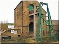
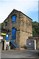
Westfield Pumping Station
Constructed in 1823, this mill still has the winding gear above the shaft, which presumably descends to the water table.
Image: © Roger May
Taken: 19 Mar 2006
0.03 miles
2
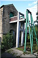
Westfield Colliery Pumping Station
Former beam engine house that is part of a large colliery pumping scheme that was still active when I took this. The engine was a Newcomen type atmospheric engine that was replaced with electric pumps.
Image: © Chris Allen
Taken: 7 Oct 2006
0.05 miles
3
Westfield Colliery Pumping Station
Former beam engine house that is part of a large colliery pumping scheme that was still active when I took this. The engine was a Newcomen type atmospheric engine that was replaced with electric pumps.
Image: © Chris Allen
Taken: 7 Oct 2006
0.05 miles
4
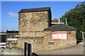
Westfield Pumping Pit Newcomen Engine House
The pit dates from 1820 and the engine house was built in 1823. This pit and engine were built to pump water away from the nearby Newbiggin Colliery.
Image: © Graham Hogg
Taken: 13 Mar 2018
0.06 miles
5
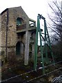
Westfield Colliery Pumping Station
Former beam engine house that is part of a large colliery pumping scheme that was still active when I took this.
Image: © Chris Allen
Taken: 7 Oct 2006
0.07 miles
6
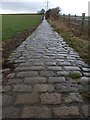
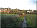
Rotherham Round Walk
This cobbled section is to the west of Rawmarsh
Image: © Graham Hogg
Taken: 13 Mar 2018
0.11 miles
7
Cobbled footpath descending towards Rawmarsh
Image: © John Slater
Taken: 7 Nov 2013
0.11 miles
8
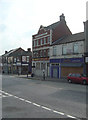
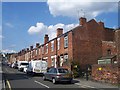
Clarence Hotel, Rawmarsh
Its function as a public house seems to have ceased quite recently - the brewer's sign is still attached.
Image: © Alan Murray-Rust
Taken: 11 May 2008
0.16 miles
10
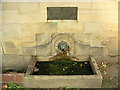
Horse War Memorial
"This trough has been placed here as a tribute to the part played by horses in the 1914-1918 war"
Image: © Christopher Thomas
Taken: 23 Sep 2005
0.16 miles