IMAGES TAKEN NEAR TO
Boundary Green, ROTHERHAM, S62 6JN
Introduction
This page details the photographs taken nearby to Boundary Green, S62 6JN by members of the Geograph project.
The Geograph project started in 2005 with the aim of publishing, organising and preserving representative images for every square kilometre of Great Britain, Ireland and the Isle of Man.

There are currently over 7.5m images from over14,400 individuals and you can help contribute to the project by visiting https://www.geograph.org.uk
Image Map
Images are licensed for reuse under creativecommons.org/licenses/by-sa/2.0
Notes
- Clicking on the map will re-center to the selected point.
- The higher the marker number, the further away the image location is from the centre of the postcode.
Image Listing (4 Images Found)
Images are licensed for reuse under creativecommons.org/licenses/by-sa/2.0
Image
Details
Distance
3
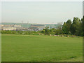
Barbers Avenue recreation ground
The eastern edge of the ground with a view over the Corus steelworks
Image: © Alan Murray-Rust
Taken: 11 May 2008
0.19 miles
4
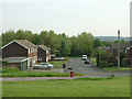
William Street
Modern housing development on the eastern edge of Rawmarsh
Image: © Alan Murray-Rust
Taken: 11 May 2008
0.21 miles