IMAGES TAKEN NEAR TO
Cornish Way, ROTHERHAM, S62 6EG
Introduction
This page details the photographs taken nearby to Cornish Way, S62 6EG by members of the Geograph project.
The Geograph project started in 2005 with the aim of publishing, organising and preserving representative images for every square kilometre of Great Britain, Ireland and the Isle of Man.

There are currently over 7.5m images from over14,400 individuals and you can help contribute to the project by visiting https://www.geograph.org.uk
Image Map
Images are licensed for reuse under creativecommons.org/licenses/by-sa/2.0
Notes
- Clicking on the map will re-center to the selected point.
- The higher the marker number, the further away the image location is from the centre of the postcode.
Image Listing (10 Images Found)
Images are licensed for reuse under creativecommons.org/licenses/by-sa/2.0
Image
Details
Distance
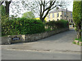
1
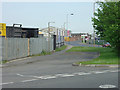
The bottom of Scrooby Lane
The road layout has been changed with the development of Mangham Road as the main road.
Image: © Alan Murray-Rust
Taken: 11 May 2008
0.12 miles
2
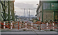
Steelworks at Parkgate
View SW on Broad Street, Parkgate, where it crossed on the level the branch off the ex-Midland main line near Parkgate & Rawmarsh Station. On the left is the water-cooling tower of the Park Gate Iron & Steel Works and ahead in the distance is the South Yorkshire Chemical Works. All is utterly different now (2011). [Location is thanks to David Atkin].
Image: © Ben Brooksbank
Taken: 23 Aug 1963
0.15 miles
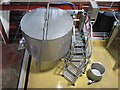
3
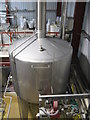
Chantry Brewery, Rotherham: Copper
Image: © Dave Pickersgill
Taken: 10 Jan 2020
0.17 miles
5
Mangham House Farm
Farming activity appears to have ceased from this site.
Image: © Alan Murray-Rust
Taken: 11 May 2008
0.19 miles
6
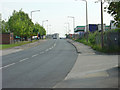
Mangham Road
This road appears to have been developed to serve the industrial estate but is also now part of the through route round the west side of Rotherham
Image: © Alan Murray-Rust
Taken: 11 May 2008
0.19 miles
7
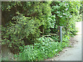
Impathible
There is a prominent signpost for the footpath, but it took several seconds to spot the stile in the undergrowth. There does not appear to be any recent use of this path, which realistically serves no significant purpose.
Image: © Alan Murray-Rust
Taken: 11 May 2008
0.19 miles

9
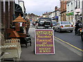
Broad Street, Rawmarsh
Looking north along Broad Street towards Rawmarsh Hill. The area is a local centre for antique shops.
Image: © Christopher Thomas
Taken: 26 Sep 2005
0.24 miles
10
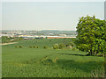
Landscape at Barbot Hall
View across to the Don valley; distant to the left is the Corus steelworks at Parkgate.
Image: © Alan Murray-Rust
Taken: 11 May 2008
0.25 miles