IMAGES TAKEN NEAR TO
Willowgarth, ROTHERHAM, S62 5RS
Introduction
This page details the photographs taken nearby to Willowgarth, S62 5RS by members of the Geograph project.
The Geograph project started in 2005 with the aim of publishing, organising and preserving representative images for every square kilometre of Great Britain, Ireland and the Isle of Man.

There are currently over 7.5m images from over14,400 individuals and you can help contribute to the project by visiting https://www.geograph.org.uk
Image Map
Images are licensed for reuse under creativecommons.org/licenses/by-sa/2.0
Notes
- Clicking on the map will re-center to the selected point.
- The higher the marker number, the further away the image location is from the centre of the postcode.
Image Listing (13 Images Found)
Images are licensed for reuse under creativecommons.org/licenses/by-sa/2.0
Image
Details
Distance
1
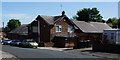
The Rawmarsh Progressive Social & Sports Club
A Sam Smith owned club on Willow Garth, Rawmarsh.
Image: © Ian S
Taken: 17 May 2014
0.13 miles
2
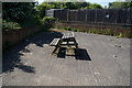
The Rawmarsh Progressive Social & Sports Club
Some of the outside seating.
Image: © Ian S
Taken: 17 May 2014
0.15 miles
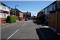
3
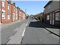
Wheatcroft Road
Wheatcroft Road in Rawmarsh demonstrates a transition in housing types. On the left are terraced/semi-detached houses fronting onto the street. On the right are later houses with small front gardens and a small boundary wall.
Image: © Michael Patterson
Taken: 18 Jul 2006
0.20 miles
4
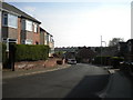
South end of Main Street, Rawmarsh
Looking towards Willow Garth.
Image: © Richard Vince
Taken: 30 Mar 2019
0.21 miles
6
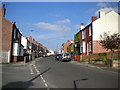
Main Street, Rawmarsh
Looking towards Kilnhurst Road.
Image: © Richard Vince
Taken: 30 Mar 2019
0.22 miles
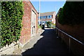
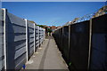
8
Ginnel to Main Street, Rawmarsh
From Dale Road, skirting the edge of the bus garage.
Image: © Richard Vince
Taken: 30 Mar 2019
0.23 miles
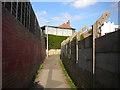
10
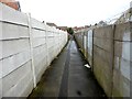
Ginnel between Main Street and Dale Road
Image: © Graham Hogg
Taken: 13 Mar 2018
0.23 miles