IMAGES TAKEN NEAR TO
Hollywell Close, ROTHERHAM, S62 5PS
Introduction
This page details the photographs taken nearby to Hollywell Close, S62 5PS by members of the Geograph project.
The Geograph project started in 2005 with the aim of publishing, organising and preserving representative images for every square kilometre of Great Britain, Ireland and the Isle of Man.

There are currently over 7.5m images from over14,400 individuals and you can help contribute to the project by visiting https://www.geograph.org.uk
Image Map
Images are licensed for reuse under creativecommons.org/licenses/by-sa/2.0
Notes
- Clicking on the map will re-center to the selected point.
- The higher the marker number, the further away the image location is from the centre of the postcode.
Image Listing (26 Images Found)
Images are licensed for reuse under creativecommons.org/licenses/by-sa/2.0
Image
Details
Distance
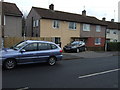
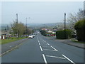
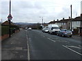
2
Thrybergh Hall Road
Junction with Kilnhurst Road.
Image: © JThomas
Taken: 9 Feb 2013
0.04 miles
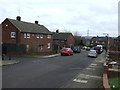
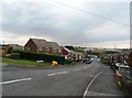
4
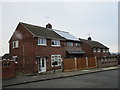
Once identical, now completely different
The changing face of suburbia.
Image: © Jonathan Thacker
Taken: 19 Jan 2019
0.05 miles
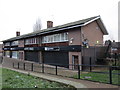
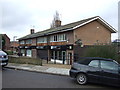
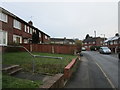
8
Dickens Road in Sandhill
Situated towards the northern fringes of Rawmarsh.
Image: © Jonathan Clitheroe
Taken: 24 Aug 2016
0.06 miles