IMAGES TAKEN NEAR TO
Cinder Bridge Road, ROTHERHAM, S61 4QP
Introduction
This page details the photographs taken nearby to Cinder Bridge Road, S61 4QP by members of the Geograph project.
The Geograph project started in 2005 with the aim of publishing, organising and preserving representative images for every square kilometre of Great Britain, Ireland and the Isle of Man.

There are currently over 7.5m images from over14,400 individuals and you can help contribute to the project by visiting https://www.geograph.org.uk
Image Map
Images are licensed for reuse under creativecommons.org/licenses/by-sa/2.0
Notes
- Clicking on the map will re-center to the selected point.
- The higher the marker number, the further away the image location is from the centre of the postcode.
Image Listing (13 Images Found)
Images are licensed for reuse under creativecommons.org/licenses/by-sa/2.0
Image
Details
Distance
2
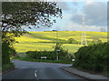
Greasbrough Lane, Greasbrough
Fields of rape presumably.
Image: © Stephen Richards
Taken: 11 May 2013
0.08 miles
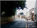
3
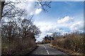
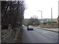
Coming up to the entrance to Wentworth Fisheries
A private road seen from The Whins.
Image: © Steve Fareham
Taken: 30 Mar 2008
0.10 miles
5
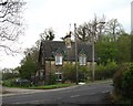
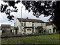
House at the entrance to Wentworth Fisheries
The telltale green paint confirms that this house still belongs to the Wentworth Woodhouse Estate.
Image: © Neil Theasby
Taken: 24 Apr 2014
0.11 miles
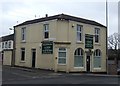
7
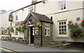
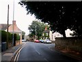
Church Street in Greasbrough
The Yellow Lion Public House can be seen on the right of picture.
Image: © Jonathan Clitheroe
Taken: 10 Aug 2016
0.18 miles