IMAGES TAKEN NEAR TO
Ginhouse Lane, ROTHERHAM, S61 4QN
Introduction
This page details the photographs taken nearby to Ginhouse Lane, S61 4QN by members of the Geograph project.
The Geograph project started in 2005 with the aim of publishing, organising and preserving representative images for every square kilometre of Great Britain, Ireland and the Isle of Man.

There are currently over 7.5m images from over14,400 individuals and you can help contribute to the project by visiting https://www.geograph.org.uk
Image Map
Images are licensed for reuse under creativecommons.org/licenses/by-sa/2.0
Notes
- Clicking on the map will re-center to the selected point.
- The higher the marker number, the further away the image location is from the centre of the postcode.
Image Listing (4 Images Found)
Images are licensed for reuse under creativecommons.org/licenses/by-sa/2.0
Image
Details
Distance
1
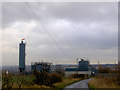
Windsock on industrial plant near Barbot Hall
Image: © Steve Fareham
Taken: 17 Jan 2008
0.11 miles
4
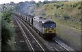
Coal from Renishaw mine nr Rotherham
Looking towards Sheffield this train load of coal has come off the freight lines that lead down to Beighton , Barrow Hill and Chesterfield the junction being situated out of view around the corner . Known as the old road the coal is heading north towards Swinton and is probably bound for one of the Aire Valley Power stations.
Image: © roger geach
Taken: 30 Aug 2000
0.25 miles