IMAGES TAKEN NEAR TO
St. Marys View, ROTHERHAM, S61 4NH
Introduction
This page details the photographs taken nearby to St. Marys View, S61 4NH by members of the Geograph project.
The Geograph project started in 2005 with the aim of publishing, organising and preserving representative images for every square kilometre of Great Britain, Ireland and the Isle of Man.

There are currently over 7.5m images from over14,400 individuals and you can help contribute to the project by visiting https://www.geograph.org.uk
Image Map
Images are licensed for reuse under creativecommons.org/licenses/by-sa/2.0
Notes
- Clicking on the map will re-center to the selected point.
- The higher the marker number, the further away the image location is from the centre of the postcode.
Image Listing (6 Images Found)
Images are licensed for reuse under creativecommons.org/licenses/by-sa/2.0
Image
Details
Distance
2
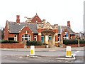
Greasbrough Public Hall
This municipal building on Coach Road roundabout was built in 1925. There is a bell tower on the rear roof, but it doesn't have the architectural style of a church.It is quite reminiscent of a school. I am indebted to Paul Eggleston - who was the person responsible for restoration work on the building when it was transferred from Greasbrough Parish Council to Rotherham MBC some years ago. He was kind enough to contact me with up-to-date information.
Image: © Roger May
Taken: 19 Mar 2006
0.17 miles
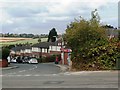
4
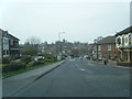
Crossroads in Greasbrough
Pictured from Munsbrough Lane.
Image: © Jonathan Clitheroe
Taken: 10 Aug 2016
0.19 miles
5
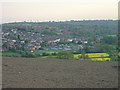
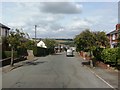
Greasbrough from The Tops
Greasbrough has developed from a separate village into an outlying suburb of Rotherham
Image: © Alan Murray-Rust
Taken: 11 May 2008
0.20 miles
6
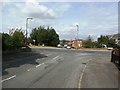
Greasbrough Post Office
Situated on Cross South Street.
Image: © Jonathan Clitheroe
Taken: 10 Aug 2016
0.22 miles