IMAGES TAKEN NEAR TO
Ochre Dike Walk, ROTHERHAM, S61 4DJ
Introduction
This page details the photographs taken nearby to Ochre Dike Walk, S61 4DJ by members of the Geograph project.
The Geograph project started in 2005 with the aim of publishing, organising and preserving representative images for every square kilometre of Great Britain, Ireland and the Isle of Man.

There are currently over 7.5m images from over14,400 individuals and you can help contribute to the project by visiting https://www.geograph.org.uk
Image Map
Images are licensed for reuse under creativecommons.org/licenses/by-sa/2.0
Notes
- Clicking on the map will re-center to the selected point.
- The higher the marker number, the further away the image location is from the centre of the postcode.
Image Listing (7 Images Found)
Images are licensed for reuse under creativecommons.org/licenses/by-sa/2.0
Image
Details
Distance


4
Private Road to the Wentworth Estate
From Coach Road Greasborough.
Image: © Steve Fareham
Taken: 18 Mar 2008
0.23 miles
7
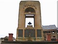
Greasbrough Cenotaph
Memorial to the fallen of Greasbrough, near St Mary's church.
Image: © Roger May
Taken: 19 Mar 2006
0.24 miles