IMAGES TAKEN NEAR TO
Fenton Croft, ROTHERHAM, S61 3ST
Introduction
This page details the photographs taken nearby to Fenton Croft, S61 3ST by members of the Geograph project.
The Geograph project started in 2005 with the aim of publishing, organising and preserving representative images for every square kilometre of Great Britain, Ireland and the Isle of Man.

There are currently over 7.5m images from over14,400 individuals and you can help contribute to the project by visiting https://www.geograph.org.uk
Image Map
Images are licensed for reuse under creativecommons.org/licenses/by-sa/2.0
Notes
- Clicking on the map will re-center to the selected point.
- The higher the marker number, the further away the image location is from the centre of the postcode.
Image Listing (10 Images Found)
Images are licensed for reuse under creativecommons.org/licenses/by-sa/2.0
Image
Details
Distance
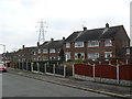
1
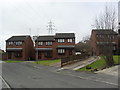
Fenton Croft
1990s houses in Rotherham.
Image: © Burgess Von Thunen
Taken: 27 Feb 2013
0.03 miles
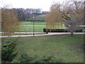
2
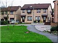
A crop of houses
This road is called Fenton Fields
Image: © Christine Johnstone
Taken: 6 Nov 2009
0.10 miles
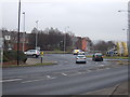
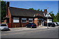
3
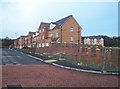
Fenton Road, Rotherham
Completed and unfinished houses on Fenton Road.
Image: © Martin Speck
Taken: 14 Jan 2009
0.17 miles
5
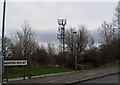
Telecoms mast Wood Mount, Kimberworth
Image: © Steve Fareham
Taken: 22 Mar 2009
0.21 miles
8
Ten Acre Road
1950s council houses in Kimberworth Park.
Image: © Burgess Von Thunen
Taken: 27 Feb 2013
0.22 miles
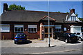
10
The Bradgate WMC, Rotherham
A Sam Smith Brewery owed club.
Image: © Ian S
Taken: 17 May 2014
0.23 miles