IMAGES TAKEN NEAR TO
Gloucester Road, ROTHERHAM, S61 3SN
Introduction
This page details the photographs taken nearby to Gloucester Road, S61 3SN by members of the Geograph project.
The Geograph project started in 2005 with the aim of publishing, organising and preserving representative images for every square kilometre of Great Britain, Ireland and the Isle of Man.

There are currently over 7.5m images from over14,400 individuals and you can help contribute to the project by visiting https://www.geograph.org.uk
Image Map
Images are licensed for reuse under creativecommons.org/licenses/by-sa/2.0
Notes
- Clicking on the map will re-center to the selected point.
- The higher the marker number, the further away the image location is from the centre of the postcode.
Image Listing (15 Images Found)
Images are licensed for reuse under creativecommons.org/licenses/by-sa/2.0
Image
Details
Distance
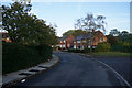
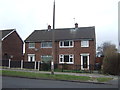
1
The Parish Church of St. John, Kimberworth, Rotherham
From Ox Close.
Image: © Steve Fareham
Taken: 22 Mar 2009
0.11 miles
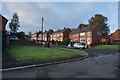
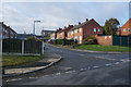
6
Celtic Court off Simmonite Road, Kimberworth Park
Image: © Ian S
Taken: 8 Oct 2014
0.19 miles
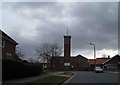
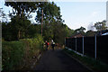
9

Coal Authority Mine Gas Monitor
On the outskirts of Kimberworth Park, Rotherham.
Image: © Ian S
Taken: 8 Oct 2014
0.22 miles