IMAGES TAKEN NEAR TO
Lodge Lane, ROTHERHAM, S61 2SF
Introduction
This page details the photographs taken nearby to Lodge Lane, S61 2SF by members of the Geograph project.
The Geograph project started in 2005 with the aim of publishing, organising and preserving representative images for every square kilometre of Great Britain, Ireland and the Isle of Man.

There are currently over 7.5m images from over14,400 individuals and you can help contribute to the project by visiting https://www.geograph.org.uk
Image Map
Images are licensed for reuse under creativecommons.org/licenses/by-sa/2.0
Notes
- Clicking on the map will re-center to the selected point.
- The higher the marker number, the further away the image location is from the centre of the postcode.
Image Listing (12 Images Found)
Images are licensed for reuse under creativecommons.org/licenses/by-sa/2.0
Image
Details
Distance

5
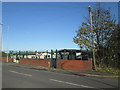
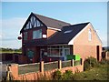
OAP and Community Centre
Looks well defended!
Image: © John Slater
Taken: 7 Nov 2013
0.15 miles
6
Post Office at Thorpe Hesley
Village post office situated on Upper Wortley Road.
Image: © Jonathan Clitheroe
Taken: 11 Jun 2011
0.16 miles

8

Playing field, Brook Hill, Thorpe Hesley
Image: © Chris Morgan
Taken: 1 Aug 2024
0.18 miles

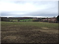
10
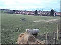
Livestock at Thorpe Common
Grazing land viewed from Jumble Lane at the southern edge of the grid square. Houses on Eldertree Road can be seen at the far side of the field.
Image: © Jonathan Clitheroe
Taken: 31 Mar 2013
0.19 miles