IMAGES TAKEN NEAR TO
Wentworth Road, ROTHERHAM, S61 2RH
Introduction
This page details the photographs taken nearby to Wentworth Road, S61 2RH by members of the Geograph project.
The Geograph project started in 2005 with the aim of publishing, organising and preserving representative images for every square kilometre of Great Britain, Ireland and the Isle of Man.

There are currently over 7.5m images from over14,400 individuals and you can help contribute to the project by visiting https://www.geograph.org.uk
Image Map
Images are licensed for reuse under creativecommons.org/licenses/by-sa/2.0
Notes
- Clicking on the map will re-center to the selected point.
- The higher the marker number, the further away the image location is from the centre of the postcode.
Image Listing (10 Images Found)
Images are licensed for reuse under creativecommons.org/licenses/by-sa/2.0
Image
Details
Distance
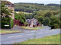
1
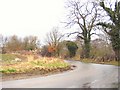
Approaching Thorpe Hesley
The last bend on Scholes Lane before it joins the road from Thorpe Hesley to Wentworth.
Image: © Roger May
Taken: 19 Mar 2006
0.15 miles
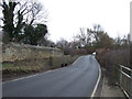
6
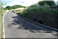
Ford at Thorpe Hesley
This part-time ford is found on the outskirts of Thorpe Hesley on Hague Lane, the road to Wentworth.
Image: © John Walton
Taken: 3 Aug 2013
0.17 miles
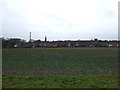
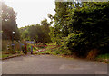
7

Field by Thorpe Hesley
Wentworth Woodhouse church on horizon to right
Image: © Chris Morgan
Taken: 1 Aug 2024
0.18 miles
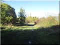
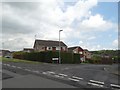
9
Gated bridleway entrance Thorpe Hesley
Complete with the usual gate to prevent off road motor bikes.
Image: © Steve Fareham
Taken: 27 Sep 2007
0.22 miles
10
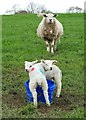
Baaa! Mother and twin lambs at Scholes
Image: © Neil Theasby
Taken: 24 Apr 2014
0.25 miles