IMAGES TAKEN NEAR TO
Heslow Grove, ROTHERHAM, S61 2PQ
Introduction
This page details the photographs taken nearby to Heslow Grove, S61 2PQ by members of the Geograph project.
The Geograph project started in 2005 with the aim of publishing, organising and preserving representative images for every square kilometre of Great Britain, Ireland and the Isle of Man.

There are currently over 7.5m images from over14,400 individuals and you can help contribute to the project by visiting https://www.geograph.org.uk
Image Map
Images are licensed for reuse under creativecommons.org/licenses/by-sa/2.0
Notes
- Clicking on the map will re-center to the selected point.
- The higher the marker number, the further away the image location is from the centre of the postcode.
Image Listing (17 Images Found)
Images are licensed for reuse under creativecommons.org/licenses/by-sa/2.0
Image
Details
Distance
1
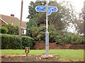
Trans Pennine Trail (TPT) junction
In Thorpe Hesley near Sheffield.
Image: © Steve Fareham
Taken: 27 Sep 2007
0.02 miles
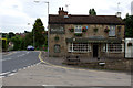

7
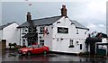
The Masons Arms
One of four public houses in Thorpe Hesley.
Image: © Graham Hogg
Taken: 23 Jun 2012
0.10 miles
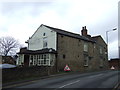
10
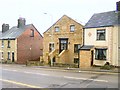
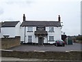
Hope Chapel 1851
This former chapel on the B6086, between Thorpe Common and Thorpe Hesley, has been converted into a stylish private house. It appears to have been built in 1851.
Image: © Roger May
Taken: 19 Mar 2006
0.18 miles