IMAGES TAKEN NEAR TO
Pitt Street, ROTHERHAM, S61 2PD
Introduction
This page details the photographs taken nearby to Pitt Street, S61 2PD by members of the Geograph project.
The Geograph project started in 2005 with the aim of publishing, organising and preserving representative images for every square kilometre of Great Britain, Ireland and the Isle of Man.

There are currently over 7.5m images from over14,400 individuals and you can help contribute to the project by visiting https://www.geograph.org.uk
Image Map
Images are licensed for reuse under creativecommons.org/licenses/by-sa/2.0
Notes
- Clicking on the map will re-center to the selected point.
- The higher the marker number, the further away the image location is from the centre of the postcode.
Image Listing (6 Images Found)
Images are licensed for reuse under creativecommons.org/licenses/by-sa/2.0
Image
Details
Distance

2
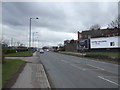
Psalters Lane Kimberworth
Psalters Lane runs from the Kimberworth Rd past the cemetery and the allotments to Meadowbank Rd.
Image: © Nigel Mykura
Taken: 4 Mar 2017
0.11 miles
4

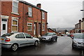
Former public house on Pitt Street, Rotherham
Image: © Ian S
Taken: 17 May 2014
0.14 miles