IMAGES TAKEN NEAR TO
Bradgate Lane, ROTHERHAM, S61 1QH
Introduction
This page details the photographs taken nearby to Bradgate Lane, S61 1QH by members of the Geograph project.
The Geograph project started in 2005 with the aim of publishing, organising and preserving representative images for every square kilometre of Great Britain, Ireland and the Isle of Man.

There are currently over 7.5m images from over14,400 individuals and you can help contribute to the project by visiting https://www.geograph.org.uk
Image Map
Images are licensed for reuse under creativecommons.org/licenses/by-sa/2.0
Notes
- Clicking on the map will re-center to the selected point.
- The higher the marker number, the further away the image location is from the centre of the postcode.
Image Listing (13 Images Found)
Images are licensed for reuse under creativecommons.org/licenses/by-sa/2.0
Image
Details
Distance
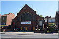
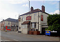
1
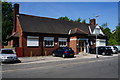
The Bradgate WMC, Rotherham
A Sam Smith Brewery owed club.
Image: © Ian S
Taken: 17 May 2014
0.02 miles
8
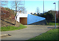
Pedestrian subway at Bradgate A6109/A629 Junction
Image: © Paul Eggleston
Taken: 2 Feb 2007
0.19 miles
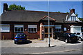
9
The Wilton Public House
En route to Meadowhall.
Image: © Steve Fareham
Taken: 28 Sep 2007
0.19 miles
10
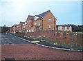
Fenton Road, Rotherham
Completed and unfinished houses on Fenton Road.
Image: © Martin Speck
Taken: 14 Jan 2009
0.22 miles