IMAGES TAKEN NEAR TO
Manor Fields, ROTHERHAM, S61 1PL
Introduction
This page details the photographs taken nearby to Manor Fields, S61 1PL by members of the Geograph project.
The Geograph project started in 2005 with the aim of publishing, organising and preserving representative images for every square kilometre of Great Britain, Ireland and the Isle of Man.

There are currently over 7.5m images from over14,400 individuals and you can help contribute to the project by visiting https://www.geograph.org.uk
Image Map
Images are licensed for reuse under creativecommons.org/licenses/by-sa/2.0
Notes
- Clicking on the map will re-center to the selected point.
- The higher the marker number, the further away the image location is from the centre of the postcode.
Image Listing (8 Images Found)
Images are licensed for reuse under creativecommons.org/licenses/by-sa/2.0
Image
Details
Distance
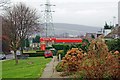
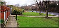
4
Manor Fields, Rotherham
High density housing under construction at Manor Fields, Rotherham.
Image: © Martin Speck
Taken: 14 Jan 2009
0.08 miles
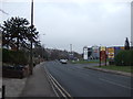
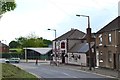
5
Wortley Road Looking Towards Thorpe Hesley
Image: © Hall Family
Taken: 25 Dec 2008
0.19 miles
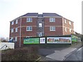
6
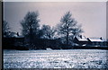
School field in winter
This is the school field at the end of Digby Close.
Image: © Alan Hawkes
Taken: 20 Jan 1971
0.19 miles
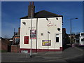
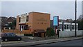
8
View of "The Colin", Kimberworth
Formerly known as "The Sir Colin Campbell" after Field Marshal Colin Campbell (1792-1863)
Image: © Neil Theasby
Taken: 5 Jul 2012
0.23 miles