IMAGES TAKEN NEAR TO
Springfields, ROTHERHAM, S60 8DR
Introduction
This page details the photographs taken nearby to Springfields, S60 8DR by members of the Geograph project.
The Geograph project started in 2005 with the aim of publishing, organising and preserving representative images for every square kilometre of Great Britain, Ireland and the Isle of Man.

There are currently over 7.5m images from over14,400 individuals and you can help contribute to the project by visiting https://www.geograph.org.uk
Image Map
Images are licensed for reuse under creativecommons.org/licenses/by-sa/2.0
Notes
- Clicking on the map will re-center to the selected point.
- The higher the marker number, the further away the image location is from the centre of the postcode.
Image Listing (6 Images Found)
Images are licensed for reuse under creativecommons.org/licenses/by-sa/2.0
Image
Details
Distance
1
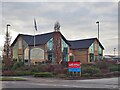
Whitby's Fish & Chip Restaurant
A popular restaurant currently offering a take away service only because of coronavirus restrictions
Image: © Graham Hogg
Taken: 4 Jan 2021
0.14 miles
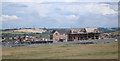
3
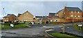
New housing by the Glassworks, Waverley
A Barratt development
Image: © Chris Morgan
Taken: 4 Jan 2021
0.19 miles
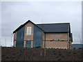
4
Track on the Waverley Development Site
Looking back towards Orgreave Road / Poplar Way.
Image: © Darren Haddock
Taken: 7 Jul 2017
0.22 miles
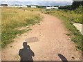
5
Waverley Housing
These houses are the first to be built on the Waverley site. This site was the former home of Orgreave Colliery and coking ovens.
Image: © John Jennings
Taken: 18 Jul 2012
0.23 miles
6
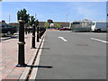
Bollards and Woolies
The bollards keep pedestrians and cars separated in this car park which is for Woolworths and Morrisons.
Image: © Michael Patterson
Taken: 14 Jul 2006
0.24 miles