IMAGES TAKEN NEAR TO
Bakewell Gardens, ROTHERHAM, S60 8AG
Introduction
This page details the photographs taken nearby to Bakewell Gardens, S60 8AG by members of the Geograph project.
The Geograph project started in 2005 with the aim of publishing, organising and preserving representative images for every square kilometre of Great Britain, Ireland and the Isle of Man.

There are currently over 7.5m images from over14,400 individuals and you can help contribute to the project by visiting https://www.geograph.org.uk
Image Map
Images are licensed for reuse under creativecommons.org/licenses/by-sa/2.0
Notes
- Clicking on the map will re-center to the selected point.
- The higher the marker number, the further away the image location is from the centre of the postcode.
Image Listing (6 Images Found)
Images are licensed for reuse under creativecommons.org/licenses/by-sa/2.0
Image
Details
Distance
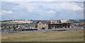
1

Wasteland - View over former Orgreave open cast mine workings
Image: © Neil Theasby
Taken: 27 Sep 2011
0.03 miles
2
Waverley Housing
These houses are the first to be built on the Waverley site. This site was the former home of Orgreave Colliery and coking ovens.
Image: © John Jennings
Taken: 18 Jul 2012
0.09 miles
3

Gated entrance to the Orgreave regeneration area
Image: © Glyn Drury
Taken: 28 Jul 2009
0.16 miles
4
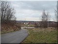
New Housing in Catcliffe
Pictured from a track near the Darnall/Woodhouse railway line.
Image: © Jonathan Clitheroe
Taken: 25 Feb 2015
0.19 miles

6
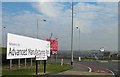
Welcome to the AMP
On the site of the Orgreave coking plant and the scene of some of the worst battles of the 1984 miners strike. Now a cluster of facilities for Boeing, Rolls Royce and theory supply chains.
Image: © Steve Fareham
Taken: 21 Oct 2012
0.25 miles