IMAGES TAKEN NEAR TO
Godric Drive, ROTHERHAM, S60 5AN
Introduction
This page details the photographs taken nearby to Godric Drive, S60 5AN by members of the Geograph project.
The Geograph project started in 2005 with the aim of publishing, organising and preserving representative images for every square kilometre of Great Britain, Ireland and the Isle of Man.

There are currently over 7.5m images from over14,400 individuals and you can help contribute to the project by visiting https://www.geograph.org.uk
Image Map
Images are licensed for reuse under creativecommons.org/licenses/by-sa/2.0
Notes
- Clicking on the map will re-center to the selected point.
- The higher the marker number, the further away the image location is from the centre of the postcode.
Image Listing (5 Images Found)
Images are licensed for reuse under creativecommons.org/licenses/by-sa/2.0
Image
Details
Distance

3
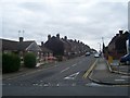
Crownhill Road
Viewed from Bonet Lane, in the foreground, these 1960s(?) semi-detached houses lead the eye down the hill and around the corner. At which point the road joins the nearby A631.
Image: © Michael Patterson
Taken: 4 Jul 2006
0.21 miles
5
Jubilee Cottages, Bawtry Road, Brinsworth.
For whatever reasons, these cottages have retained their uniform status. The style of architecture suggests the 1935 Jubilee as the year of construction.
Image: © Alan Murray-Rust
Taken: 11 May 2008
0.24 miles