IMAGES TAKEN NEAR TO
Upper Whiston, Whiston, ROTHERHAM, S60 4NG
Introduction
This page details the photographs taken nearby to S60 4NG by members of the Geograph project.
The Geograph project started in 2005 with the aim of publishing, organising and preserving representative images for every square kilometre of Great Britain, Ireland and the Isle of Man.

There are currently over 7.5m images from over14,400 individuals and you can help contribute to the project by visiting https://www.geograph.org.uk
Image Map
Images are licensed for reuse under creativecommons.org/licenses/by-sa/2.0
Notes
- Clicking on the map will re-center to the selected point.
- The higher the marker number, the further away the image location is from the centre of the postcode.
Image Listing (35 Images Found)
Images are licensed for reuse under creativecommons.org/licenses/by-sa/2.0
Image
Details
Distance
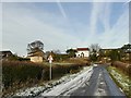
1
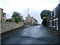
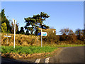
Upper Whiston
Hamlet located close to the M1 motorway.
Image: © Jonathan Clitheroe
Taken: 29 Jun 2016
0.01 miles
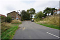
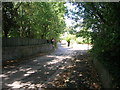
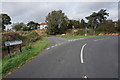
4
Road junction at Upper Whiston.
Taken on a walk from Ulley country park.
Image: © steven ruffles
Taken: 20 May 2015
0.02 miles
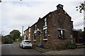
6
Guilthwaite Common Lane at Upper Whiston Lane
Image: © Ian S
Taken: 19 Sep 2018
0.03 miles