IMAGES TAKEN NEAR TO
Herringthorpe Valley Road, ROTHERHAM, S60 4LA
Introduction
This page details the photographs taken nearby to Herringthorpe Valley Road, S60 4LA by members of the Geograph project.
The Geograph project started in 2005 with the aim of publishing, organising and preserving representative images for every square kilometre of Great Britain, Ireland and the Isle of Man.

There are currently over 7.5m images from over14,400 individuals and you can help contribute to the project by visiting https://www.geograph.org.uk
Image Map
Images are licensed for reuse under creativecommons.org/licenses/by-sa/2.0
Notes
- Clicking on the map will re-center to the selected point.
- The higher the marker number, the further away the image location is from the centre of the postcode.
Image Listing (21 Images Found)
Images are licensed for reuse under creativecommons.org/licenses/by-sa/2.0
Image
Details
Distance
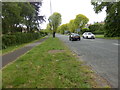
1
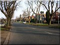
Rotherham Suburb
Looking in a northerly direction towards Herringthorpe.
Image: © Andrew Loughran
Taken: 24 Jan 2006
0.06 miles
4
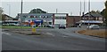
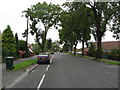
Shops in Herringthorpe
Many of the buildings in this area are 1960s vintage.
Image: © Peter Church
Taken: 13 Oct 2007
0.13 miles
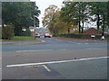
7
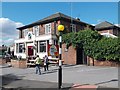
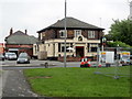
"The Stag", Stag Roundabout, Rotherham
Image: © Neil Theasby
Taken: 16 Aug 2013
0.15 miles
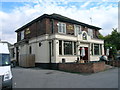
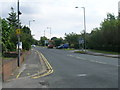
8
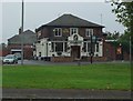
The Stag
Public House in Herringthorpe, a suburb of Rotherham.
Image: © Peter Church
Taken: 13 Oct 2007
0.15 miles