IMAGES TAKEN NEAR TO
Barfield Avenue, ROTHERHAM, S60 4EY
Introduction
This page details the photographs taken nearby to Barfield Avenue, S60 4EY by members of the Geograph project.
The Geograph project started in 2005 with the aim of publishing, organising and preserving representative images for every square kilometre of Great Britain, Ireland and the Isle of Man.

There are currently over 7.5m images from over14,400 individuals and you can help contribute to the project by visiting https://www.geograph.org.uk
Image Map
Images are licensed for reuse under creativecommons.org/licenses/by-sa/2.0
Notes
- Clicking on the map will re-center to the selected point.
- The higher the marker number, the further away the image location is from the centre of the postcode.
Image Listing (30 Images Found)
Images are licensed for reuse under creativecommons.org/licenses/by-sa/2.0
Image
Details
Distance
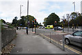
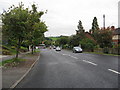
5
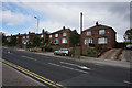
Whiston - Pleasley Road, Nr Rotherham
View taken at Whiston traffic lights.
Image: © Andrew Loughran
Taken: 24 Jan 2006
0.07 miles
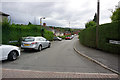
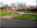
8
Pleasley Road (A618)
View having just left the East Bawtry Road (A631).
Image: © Alan Heardman
Taken: 9 Sep 2008
0.11 miles
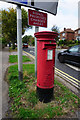
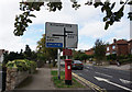
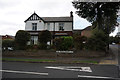
9
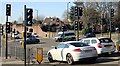
Whiston Crossroads
Whiston Crossroads where four roads meet, namely East and West Bawtry Roads, Moorgate Road and Pleasley Road. These traffic lights are on the East Bawtry Road side of the junction.
Image: © Ryk Rak
Taken: 27 Feb 2019
0.11 miles