IMAGES TAKEN NEAR TO
Leasegate Road, ROTHERHAM, S60 4ER
Introduction
This page details the photographs taken nearby to Leasegate Road, S60 4ER by members of the Geograph project.
The Geograph project started in 2005 with the aim of publishing, organising and preserving representative images for every square kilometre of Great Britain, Ireland and the Isle of Man.

There are currently over 7.5m images from over14,400 individuals and you can help contribute to the project by visiting https://www.geograph.org.uk
Image Map
Images are licensed for reuse under creativecommons.org/licenses/by-sa/2.0
Notes
- Clicking on the map will re-center to the selected point.
- The higher the marker number, the further away the image location is from the centre of the postcode.
Image Listing (4 Images Found)
Images are licensed for reuse under creativecommons.org/licenses/by-sa/2.0
Image
Details
Distance
1
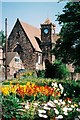
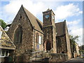
Whiston: church and flowers
A colourful scene in Whiston.
Image: © Chris Downer
Taken: Unknown
0.22 miles
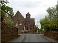
3
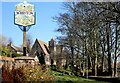
Whiston Village
Whiston village sign board in the foreground and the High Street church in the background.
Image: © Ryk Rak
Taken: 27 Feb 2019
0.23 miles