IMAGES TAKEN NEAR TO
Rhodes Drive, ROTHERHAM, S60 4AY
Introduction
This page details the photographs taken nearby to Rhodes Drive, S60 4AY by members of the Geograph project.
The Geograph project started in 2005 with the aim of publishing, organising and preserving representative images for every square kilometre of Great Britain, Ireland and the Isle of Man.

There are currently over 7.5m images from over14,400 individuals and you can help contribute to the project by visiting https://www.geograph.org.uk
Image Map
Images are licensed for reuse under creativecommons.org/licenses/by-sa/2.0
Notes
- Clicking on the map will re-center to the selected point.
- The higher the marker number, the further away the image location is from the centre of the postcode.
Image Listing (7 Images Found)
Images are licensed for reuse under creativecommons.org/licenses/by-sa/2.0
Image
Details
Distance
2
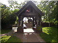
Lych Gate
The Lych Gates are the main entrance to and from the church yard. Image is facing west from the church's main entrance.
Image: © Dave Thackery
Taken: 7 Jun 2006
0.18 miles
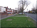
4
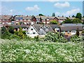
Houses in Whiston
I believe the ostentatious house in the centre is called Delft Cottage and is on Moorhouse Lane.
Image: © Neil Theasby
Taken: 31 May 2013
0.19 miles
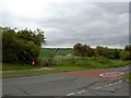
5
Worrygoose Lane
The B6140, heading east to Whiston and the motorway [M1 and M18] from Bawtry Road, Rotherham.
Image: © M J Richardson
Taken: 2 Mar 2011
0.20 miles
6
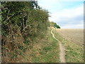
Footpath from Worrygoose Lane
Looking from the junction with Cow Rakes Lane.
Image: © Steve Fareham
Taken: 27 May 2009
0.20 miles
7
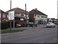
Shops on Worrygoose Lane
Local facilities at the junction of Bawtry Road [A631], Broom Lane, Herringthorpe Valley Road [A6123] and Worrygoose Lane [B6410].
Image: © M J Richardson
Taken: 2 Mar 2011
0.22 miles