IMAGES TAKEN NEAR TO
Acres View, ROTHERHAM, S60 3JY
Introduction
This page details the photographs taken nearby to Acres View, S60 3JY by members of the Geograph project.
The Geograph project started in 2005 with the aim of publishing, organising and preserving representative images for every square kilometre of Great Britain, Ireland and the Isle of Man.

There are currently over 7.5m images from over14,400 individuals and you can help contribute to the project by visiting https://www.geograph.org.uk
Image Map
Images are licensed for reuse under creativecommons.org/licenses/by-sa/2.0
Notes
- Clicking on the map will re-center to the selected point.
- The higher the marker number, the further away the image location is from the centre of the postcode.
Image Listing (10 Images Found)
Images are licensed for reuse under creativecommons.org/licenses/by-sa/2.0
Image
Details
Distance
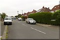
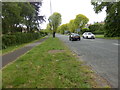
3
Broom Lane approach to the Worry Goose Roundabout
Image: © Alan Heardman
Taken: 9 Sep 2008
0.15 miles
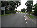
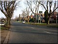
6
Worrygoose roundabout
Strange named roundabout on Herringthorpe Valley Road Rotherham.
Image: © Steve Fareham
Taken: 6 Nov 2007
0.17 miles
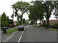
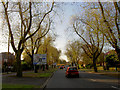
7
Rotherham Suburb
Looking in a northerly direction towards Herringthorpe.
Image: © Andrew Loughran
Taken: 24 Jan 2006
0.17 miles
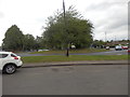
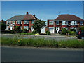
9
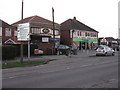
Shops on Worrygoose Lane
Local facilities at the junction of Bawtry Road [A631], Broom Lane, Herringthorpe Valley Road [A6123] and Worrygoose Lane [B6410].
Image: © M J Richardson
Taken: 2 Mar 2011
0.22 miles
10
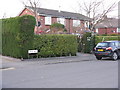
Lathe Road, Whiston
At its junction with Worrygoose Lane.
Image: © M J Richardson
Taken: 2 Mar 2011
0.23 miles