IMAGES TAKEN NEAR TO
Rother View Road, ROTHERHAM, S60 2UT
Introduction
This page details the photographs taken nearby to Rother View Road, S60 2UT by members of the Geograph project.
The Geograph project started in 2005 with the aim of publishing, organising and preserving representative images for every square kilometre of Great Britain, Ireland and the Isle of Man.

There are currently over 7.5m images from over14,400 individuals and you can help contribute to the project by visiting https://www.geograph.org.uk
Image Map (18 Images)


Getting Data...Please wait
Leaflet Map data © OpenStreetMap
Images are licensed for reuse under creativecommons.org/licenses/by-sa/2.0
Notes
- Clicking on the map will re-center to the selected point.
- The higher the marker number, the further away the image location is from the centre of the postcode.
Image Listing (18 Images Found)
Images are licensed for reuse under creativecommons.org/licenses/by-sa/2.0
Image
Details
Distance

2
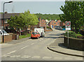
Canklow Hill Road
A substantial new housing development is nearing completion on the hillside.
Image: © Alan Murray-Rust
Taken: 11 May 2008
0.07 miles

5
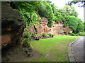
Old Sandstone Quarry in Boston Park
Set into the face of this old sandstone quarry, is the 17th century doorway from a demolished Rotherham town building that incorporated the remains of the medieval College of Jesus founded by Thomas Rotherham in 1483 (centre of picture). The sandstone, known as Rotherham or Mexborough Red Rock, was extensively quarried in the area and is evident in many buildings in the town.
Image: © Nikki Mahadevan
Taken: 24 Jun 2006
0.18 miles
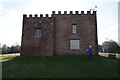
6
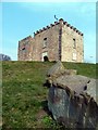
Boston Castle
A former shooting lodge owned by Thomas Howard, Earl of Effingham and built in 1775. It is named from Boston, Massachusetts, the scene of the Boston Tea Party of 1775, the Earl having supported the struggle of the American colonialists against the British Crown.
Image: © Graham Hogg
Taken: 10 Apr 2013
0.19 miles
7
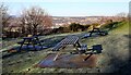
Boston Park Picnic Area
The picnic area is next to Boston Castle out of shot to the right hand side of the image.
Image: © Ryk Rak
Taken: 23 Jan 2019
0.21 miles
8
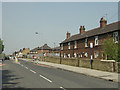
Canklow Road
The old main road has been superseded for through traffic by the new Centenary Way and has been further provided with traffic calming measures. Note that the old terraced housing along the main road has been cut into by the development of the later council estate behind it.
Image: © Alan Murray-Rust
Taken: 11 May 2008
0.22 miles
10
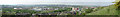
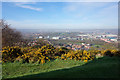
Don and Rother Valley panorama
This area used to be dominated by the steel making and associated industries, but has been redeveloped with modern industrial estates. Click 'more sizes' to see the full size version of the image.
For even better detail, the constituent images are Image Image Image Image
Image: © Alan Murray-Rust
Taken: 11 May 2008
0.22 miles