IMAGES TAKEN NEAR TO
Canklow Road, ROTHERHAM, S60 2JQ
Introduction
This page details the photographs taken nearby to Canklow Road, S60 2JQ by members of the Geograph project.
The Geograph project started in 2005 with the aim of publishing, organising and preserving representative images for every square kilometre of Great Britain, Ireland and the Isle of Man.

There are currently over 7.5m images from over14,400 individuals and you can help contribute to the project by visiting https://www.geograph.org.uk
Image Map
Images are licensed for reuse under creativecommons.org/licenses/by-sa/2.0
Notes
- Clicking on the map will re-center to the selected point.
- The higher the marker number, the further away the image location is from the centre of the postcode.
Image Listing (27 Images Found)
Images are licensed for reuse under creativecommons.org/licenses/by-sa/2.0
Image
Details
Distance
1
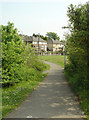
Footpath from Canklow Road
Linking to the footpath along the River Rother itself.
Image: © Alan Murray-Rust
Taken: 11 May 2008
0.03 miles
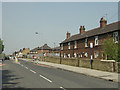
2

Houses on Jubilee Street
Part of the Canklow Road estate seen from the steep hillside above the Rother Valley. The steepness of the road is not obvious in this view.
Image: © Alan Murray-Rust
Taken: 11 May 2008
0.03 miles
3
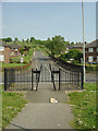
Looking up Jubilee Street
Formerly there would have been a row of houses across the top end of the street, but it now opens directly onto the open space of Canklow Hill.
Image: © Alan Murray-Rust
Taken: 11 May 2008
0.04 miles
4
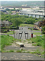
Jubilee Street from Canklow Hill
The stepped footpath in what appears to be simply open space gives the lie to the fact that there used to be housing on this side of the nearest road.
Image: © Alan Murray-Rust
Taken: 11 May 2008
0.04 miles
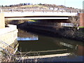
5

River Rother at Canklow
Taken from the Centenary Way bridge. The footpath is part of the Trans Pennine Trail
Image: © Alan Murray-Rust
Taken: 11 May 2008
0.06 miles
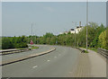
7
Canklow Road
The old main road has been superseded for through traffic by the new Centenary Way and has been further provided with traffic calming measures. Note that the old terraced housing along the main road has been cut into by the development of the later council estate behind it.
Image: © Alan Murray-Rust
Taken: 11 May 2008
0.10 miles
8

Rother View Road
The Magic map shows a continuous row of houses on this side of the road as well, possibly in the same style as those visible, but they have disappeared without trace. They have already disappeared too from the 1:25000 and 1:50000 maps.
Image: © Alan Murray-Rust
Taken: 11 May 2008
0.11 miles
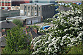
9
Centenary Way
This is where it crosses the River Rother. The Rank Hovis flour mill can be seen over the tree.
Image: © Alan Murray-Rust
Taken: 11 May 2008
0.11 miles
10
May in May
May blossom on the hillside above Canklow Road
Image: © Alan Murray-Rust
Taken: 11 May 2008
0.13 miles