IMAGES TAKEN NEAR TO
Mansfield Road, ROTHERHAM, S60 2DT
Introduction
This page details the photographs taken nearby to Mansfield Road, S60 2DT by members of the Geograph project.
The Geograph project started in 2005 with the aim of publishing, organising and preserving representative images for every square kilometre of Great Britain, Ireland and the Isle of Man.

There are currently over 7.5m images from over14,400 individuals and you can help contribute to the project by visiting https://www.geograph.org.uk
Image Map
Images are licensed for reuse under creativecommons.org/licenses/by-sa/2.0
Notes
- Clicking on the map will re-center to the selected point.
- The higher the marker number, the further away the image location is from the centre of the postcode.
Image Listing (133 Images Found)
Images are licensed for reuse under creativecommons.org/licenses/by-sa/2.0
Image
Details
Distance
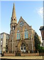
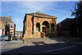
2
Jamia Masjid Ahl E Hadith and Moorgate A H Community Centre
Image: © Jonathan Thacker
Taken: 29 Jan 2011
0.03 miles
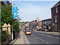
3
Wellgate, Rotherham
Wellgate, looking north-west towards Rotherham town centre.
Image: © Christopher Thomas
Taken: 28 Sep 2005
0.04 miles
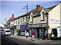
6
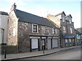
Old houses, Moorgate Street
Now in commercial use.
Image: © Jonathan Thacker
Taken: 29 Jan 2011
0.05 miles
7
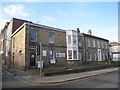
Old houses, Moorgate Street (2)
Now in commercial use.
Image: © Jonathan Thacker
Taken: 29 Jan 2011
0.06 miles
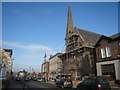
8
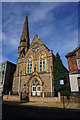
Jamiat Ahle Hadith, a Masjid on Moorgate Street, Rotherham
Image: © Ian S
Taken: 19 Sep 2018
0.06 miles
9
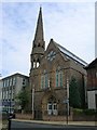
Moorgate Street Mosque, Rotherham previously the Unitarian Church
Image: © JThomas
Taken: 2 Sep 2011
0.07 miles