IMAGES TAKEN NEAR TO
Moorgate, ROTHERHAM, S60 2BE
Introduction
This page details the photographs taken nearby to Moorgate, S60 2BE by members of the Geograph project.
The Geograph project started in 2005 with the aim of publishing, organising and preserving representative images for every square kilometre of Great Britain, Ireland and the Isle of Man.

There are currently over 7.5m images from over14,400 individuals and you can help contribute to the project by visiting https://www.geograph.org.uk
Image Map
Images are licensed for reuse under creativecommons.org/licenses/by-sa/2.0
Notes
- Clicking on the map will re-center to the selected point.
- The higher the marker number, the further away the image location is from the centre of the postcode.
Image Listing (35 Images Found)
Images are licensed for reuse under creativecommons.org/licenses/by-sa/2.0
Image
Details
Distance
1

Thomas Rotherham College
On Moorgate Road, Rotherham.
Image: © Ian S
Taken: 13 Apr 2016
0.02 miles
2
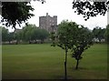
Rotherham Grammar School
This was firstly the College of Jesus founded in 1481/2 by Thomas Rotherham Archbishop of York. Later it became Rotherham Grammar School for Boys until 1967 when it became The Thomas Rotherham College.
Image: © Chris Field
Taken: 30 Jun 2003
0.02 miles
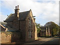
5
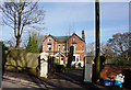
Woodfield Villas, Boston Castle Grove, Rotherham
Image: © Ian S
Taken: 13 Apr 2016
0.06 miles
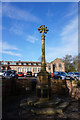
8

Milepost on the A618
The town of Clowne has gained an 'E' since this milepost was placed. In the background is Thomas Rotherham College
Image: © Graham Hogg
Taken: 10 Apr 2013
0.08 miles
10

Milestone, Moorgate Rd
Metal plate backed with what looks like stone. see other views https://www.geograph.org.uk/photo/3406566 & http://www.geograph.org.uk/photo/6741219
Rotherham & Pleasely Road / Rotherham College Square 1 / Mansfield Town 22½ / Pleasely Old Cross 19½ / Clown 11½
Grade II listed by Historic England. see https://historicengland.org.uk/listing/the-list/list-entry/1132716
Milestone Society National ID: YS_RMPL02
Image: © Caroline Brash
Taken: 25 Jul 2020
0.09 miles