IMAGES TAKEN NEAR TO
Moorgate Road, ROTHERHAM, S60 2AW
Introduction
This page details the photographs taken nearby to Moorgate Road, S60 2AW by members of the Geograph project.
The Geograph project started in 2005 with the aim of publishing, organising and preserving representative images for every square kilometre of Great Britain, Ireland and the Isle of Man.

There are currently over 7.5m images from over14,400 individuals and you can help contribute to the project by visiting https://www.geograph.org.uk
Image Map
Images are licensed for reuse under creativecommons.org/licenses/by-sa/2.0
Notes
- Clicking on the map will re-center to the selected point.
- The higher the marker number, the further away the image location is from the centre of the postcode.
Image Listing (27 Images Found)
Images are licensed for reuse under creativecommons.org/licenses/by-sa/2.0
Image
Details
Distance
1
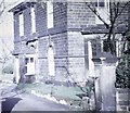
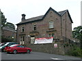
Victorian House, Mountenoy Road
This stone built house had been divided into two flats in the 1960s. It looks out over the Don Valley and the steel works to views of the Derbyshire Moors the far side of Sheffield.
Image: © Alan Hawkes
Taken: 10 Sep 1970
0.03 miles
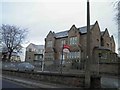
3
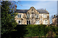
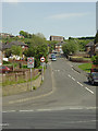
Houses on Moorgate Road, Rotherham
Built in 1878.
Image: © Ian S
Taken: 13 Apr 2016
0.13 miles
4
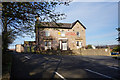
Modern China @ The Florence
On Moorgate Road, Rotherham. http://www.geograph.org.uk/photo/4905588
Image: © Ian S
Taken: 13 Apr 2016
0.16 miles
5

Don and Rother Valley panorama ( part 1)
Looking NNW with Rotherham centre to the right; the dark spire of the parish church is just discernible. The yellow rape fields are Barbot Hill behind which lies Greasbrough. The Canklow Road estate is just in view bottom left with the large Rank Hovis mill behind. This is one of seven pictures used to create the panorama pictureImage
Image: © Alan Murray-Rust
Taken: 11 May 2008
0.16 miles
6
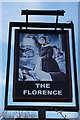
Modern China @ The Florence
On Moorgate Road, Rotherham. http://www.geograph.org.uk/photo/4905585
Image: © Ian S
Taken: 13 Apr 2016
0.17 miles
7
Mill Street
The north end of the Canklow Road estate. The road derives its name from the flour mill behind the photographer.
Image: © Alan Murray-Rust
Taken: 11 May 2008
0.18 miles
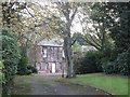
10
Apartments on Moorgate
Up to about 2004 this building was the corporate HQ of AMCO Corporation plc.
Image: © Steve Fareham
Taken: 12 Dec 2012
0.18 miles