IMAGES TAKEN NEAR TO
Rawmarsh Road, ROTHERHAM, S60 1RZ
Introduction
This page details the photographs taken nearby to Rawmarsh Road, S60 1RZ by members of the Geograph project.
The Geograph project started in 2005 with the aim of publishing, organising and preserving representative images for every square kilometre of Great Britain, Ireland and the Isle of Man.

There are currently over 7.5m images from over14,400 individuals and you can help contribute to the project by visiting https://www.geograph.org.uk
Image Map
Images are licensed for reuse under creativecommons.org/licenses/by-sa/2.0
Notes
- Clicking on the map will re-center to the selected point.
- The higher the marker number, the further away the image location is from the centre of the postcode.
Image Listing (17 Images Found)
Images are licensed for reuse under creativecommons.org/licenses/by-sa/2.0
Image
Details
Distance
1
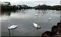
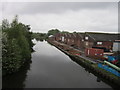
Swans on the canal
Over 100 mute swans on this basin on the Sheffield & South Yorkshire Navigation at Parkgate
Image: © Graham Hogg
Taken: 13 Mar 2018
0.03 miles
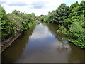
3
Grafton Old Bridge
Grafton Old Bridge, also known as the Don Bridge, as seen in March 2009. The bridge was built in 1876 by Armstrong and Co of Brinsworth Iron & Steel Works. In the 2007 floods the bridge caused significant obstruction to the flow of the Don when debris built up behind it. It was demolished in October 2009.
Image: © Martin Speck
Taken: 22 Mar 2009
0.07 miles
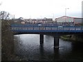
5
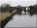
Rotherham - Rawmarsh Road bridge
This is the bridge carrying Rawmarsh Road over the Don Navigation, viewed from the towpath alongside the Navigation basin.
Image: © Dave Bevis
Taken: 17 Jan 2011
0.11 miles
6
Building on Forge Way, Rotherham
A view from a train on the North Midland Railway line to the north of Rotherham, with vacant land between the line and the railway serving Rotherham station itself. The unidintified building is recent. Mapped on the left are a pumping station and sluice. Behind is the eastern side of Rotherham, largely in Image
Image: © Derek Harper
Taken: 31 Mar 2012
0.13 miles
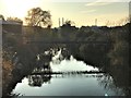
7
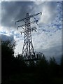
End of the line
The power distribution network disappears underground at this point.
Image: © Martin Speck
Taken: 18 May 2008
0.13 miles
9
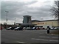
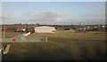
Rotherham's new leisure complex
Looking from Effingham Street, Eastwood.
Image: © Steve Fareham
Taken: 22 Mar 2009
0.14 miles
10
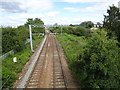
Rotherham Road railway station (site), Yorkshire
Opened in 1871 as "Park Gate" by the Manchester Sheffield & Lincolnshire Railway, which later changed its name to the Great Central Railway, on the line from Rotherham Central to Doncaster. This station's name was changed to "Rotherham Road" in 1895. It closed to passengers in 1953.
View north east towards Parkgate & Aldwarke and Doncaster. The north-east end of the 2 parallel platforms would have been immediately below the camera position but the modern Rotherham Road bridge has been built right over the top of where the station building would have been.
The line was electrified in 2018 for use by the South Yorkshire Supertram which now shares the line.
Image: © Nigel Thompson
Taken: 11 Jul 2020
0.14 miles