IMAGES TAKEN NEAR TO
Bridgegate, ROTHERHAM, S60 1PL
Introduction
This page details the photographs taken nearby to Bridgegate, S60 1PL by members of the Geograph project.
The Geograph project started in 2005 with the aim of publishing, organising and preserving representative images for every square kilometre of Great Britain, Ireland and the Isle of Man.

There are currently over 7.5m images from over14,400 individuals and you can help contribute to the project by visiting https://www.geograph.org.uk
Image Map
Images are licensed for reuse under creativecommons.org/licenses/by-sa/2.0
Notes
- Clicking on the map will re-center to the selected point.
- The higher the marker number, the further away the image location is from the centre of the postcode.
Image Listing (253 Images Found)
Images are licensed for reuse under creativecommons.org/licenses/by-sa/2.0
Image
Details
Distance
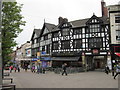
6
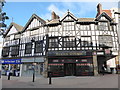
Splendid mock Tudor business premises opposite the Minster
Image: © Basher Eyre
Taken: 25 Oct 2018
0.04 miles
9
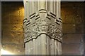
Green Man
One of several Green Man carvings in All Saints' church, this 15th century one on a nave capital http://www.geograph.org.uk/photo/1138635
Image: © Richard Croft
Taken: 27 Jan 2009
0.05 miles
10
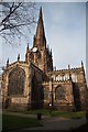
All Saints' church
Grand cruciform Perpendicular church with a 180ft spire
Image: © Richard Croft
Taken: 27 Jan 2009
0.05 miles