IMAGES TAKEN NEAR TO
Thornhill Edge, ROTHERHAM, S60 1JT
Introduction
This page details the photographs taken nearby to Thornhill Edge, S60 1JT by members of the Geograph project.
The Geograph project started in 2005 with the aim of publishing, organising and preserving representative images for every square kilometre of Great Britain, Ireland and the Isle of Man.

There are currently over 7.5m images from over14,400 individuals and you can help contribute to the project by visiting https://www.geograph.org.uk
Image Map
Images are licensed for reuse under creativecommons.org/licenses/by-sa/2.0
Notes
- Clicking on the map will re-center to the selected point.
- The higher the marker number, the further away the image location is from the centre of the postcode.
Image Listing (46 Images Found)
Images are licensed for reuse under creativecommons.org/licenses/by-sa/2.0
Image
Details
Distance
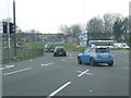
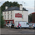
2
Is there a B&Q in Rotherham?
Well not, anymore, at this location! ... and despite the sign Burleys Diner is closed too! Image
Image: © Terry Robinson
Taken: 24 Oct 2009
0.12 miles
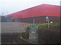
3
Camelot Play Castle on Tenter Street, Rotherham
Image: © Ian S
Taken: 8 Oct 2014
0.14 miles
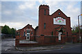
5
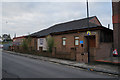
Kingdom Hall of Jehovah's Witnesses
On Thames Street, Rotherham.
Image: © Ian S
Taken: 8 Oct 2014
0.16 miles
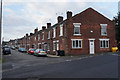
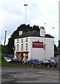
6
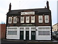
Rotherham - Royal Standard
On Masbrough Street.
Image: © Dave Bevis
Taken: 5 Dec 2008
0.16 miles
8
The Kingfisher public house, Mary Street, Rotherham
Image: © Ian S
Taken: 8 Oct 2014
0.17 miles
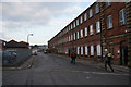
10

Russums Catering Clothing & Equipment
On Tenter Street, Rotherham.
Image: © Ian S
Taken: 8 Oct 2014
0.18 miles