IMAGES TAKEN NEAR TO
St. Bedes Road, ROTHERHAM, S60 1HG
Introduction
This page details the photographs taken nearby to St. Bedes Road, S60 1HG by members of the Geograph project.
The Geograph project started in 2005 with the aim of publishing, organising and preserving representative images for every square kilometre of Great Britain, Ireland and the Isle of Man.

There are currently over 7.5m images from over14,400 individuals and you can help contribute to the project by visiting https://www.geograph.org.uk
Image Map
Images are licensed for reuse under creativecommons.org/licenses/by-sa/2.0
Notes
- Clicking on the map will re-center to the selected point.
- The higher the marker number, the further away the image location is from the centre of the postcode.
Image Listing (34 Images Found)
Images are licensed for reuse under creativecommons.org/licenses/by-sa/2.0
Image
Details
Distance
2
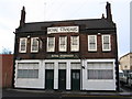
Rotherham - Royal Standard
On Masbrough Street.
Image: © Dave Bevis
Taken: 5 Dec 2008
0.12 miles
3

Rotherham - Primitive Methodist Chapel
Now a Sea Scouts hall.
Image: © Dave Bevis
Taken: 5 Dec 2008
0.13 miles
5
Rotherham - Prince of Wales Hotel
On Station Road, opposite Masborough Station.
Image: © Dave Bevis
Taken: 5 Dec 2008
0.18 miles
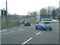
7
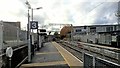
Rotherham Central station
Showing lower level Platforms 3 and 4 for Supertram Tram-trains.
Image: © Chris Morgan
Taken: 7 Nov 2018
0.19 miles
8
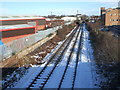
Rotherham Central railway station (site), Yorkshire, 2009
Opened in 1868 by the South Yorkshire Railway on what became the line from Sheffield Victoria to Doncaster, this station closed in 1966. View north towards Rotherham Road and Doncaster. The main building was in the right foreground. A new Rotherham Central was opened in 1987 which can be seen in the distance. The railway line was electrified for tram-train some 9 years after this image was taken.
Image: © Nigel Thompson
Taken: 7 Feb 2009
0.19 miles
9

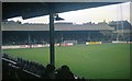
Rotherham - Millmoor Lane - Masbrough Street End
Booth's Scrapyard is on the east side of the alley and Rotherham United's Millmoor Stadium is on the west. This was the recommended walking route for away supporters arriving at Rotherham Central Station. For the 2008-2009 season, Rotherham United have re-located to Don Valley Stadium.
Image: © Dave Bevis
Taken: 5 Dec 2008
0.20 miles
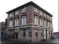
10
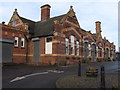
Rotherham - Masborough Station
This is the frontage of the (closed) Midland Railway station. Rail travellers now use Rotherham Central Station.
Image: © Dave Bevis
Taken: 5 Dec 2008
0.21 miles