IMAGES TAKEN NEAR TO
Magna Way, ROTHERHAM, S60 1FD
Introduction
This page details the photographs taken nearby to Magna Way, S60 1FD by members of the Geograph project.
The Geograph project started in 2005 with the aim of publishing, organising and preserving representative images for every square kilometre of Great Britain, Ireland and the Isle of Man.

There are currently over 7.5m images from over14,400 individuals and you can help contribute to the project by visiting https://www.geograph.org.uk
Image Map
Images are licensed for reuse under creativecommons.org/licenses/by-sa/2.0
Notes
- Clicking on the map will re-center to the selected point.
- The higher the marker number, the further away the image location is from the centre of the postcode.
Image Listing (34 Images Found)
Images are licensed for reuse under creativecommons.org/licenses/by-sa/2.0
Image
Details
Distance
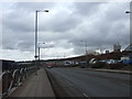
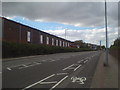
1

Parcel Force Worldwide depot
Replaces older premises at Parkgate.
Image: © Jonathan Thacker
Taken: 6 May 2015
0.08 miles
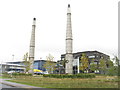
2
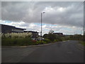
Clouds over Magna Way
Magna Science Adventure Centre in the background
Image: © Schlosser67
Taken: 5 Oct 2016
0.09 miles
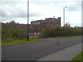
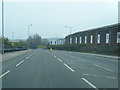
6
Magna Business Park
With relics of the original steelmaking industry on the site as features.
Image: © M J Richardson
Taken: 11 Oct 2011
0.13 miles
7
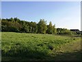
Blackburn Meadows Nature Reserve
Magna Science Adventure Centre can be also seen on the right of picture.
Image: © Jonathan Clitheroe
Taken: 10 May 2017
0.14 miles
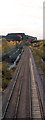
9
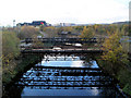
Bridges over River Don on Bessemer Way
The Magna centre is in the background.
Image: © Steve Fareham
Taken: 11 Nov 2007
0.15 miles