IMAGES TAKEN NEAR TO
Mill Close, ROTHERHAM, S60 1BZ
Introduction
This page details the photographs taken nearby to Mill Close, S60 1BZ by members of the Geograph project.
The Geograph project started in 2005 with the aim of publishing, organising and preserving representative images for every square kilometre of Great Britain, Ireland and the Isle of Man.

There are currently over 7.5m images from over14,400 individuals and you can help contribute to the project by visiting https://www.geograph.org.uk
Image Map
Images are licensed for reuse under creativecommons.org/licenses/by-sa/2.0
Notes
- Clicking on the map will re-center to the selected point.
- The higher the marker number, the further away the image location is from the centre of the postcode.
Image Listing (30 Images Found)
Images are licensed for reuse under creativecommons.org/licenses/by-sa/2.0
Image
Details
Distance
1
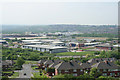
Don and Rother Valley panorama ( part 3)
Looking north of west onto the Don Valley. In the foreground part of the Canklow Road estate with the Rother and Centenary Way immediately beyond. The centre of the picture is taken up by the Templegate Industrial Estate which has superseded the more traditional industries. On the far hillside is the suburb of Kimberworth. This is one of seven pictures used to create the panorama picture Image
Image: © Alan Murray-Rust
Taken: 11 May 2008
0.03 miles
2
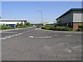
Dodds Close
Dodds Close is also close to the River Rother which flows past the other end of this road. These buildings form part of a larger industrial development in this area.
Image: © Michael Patterson
Taken: 18 Jul 2006
0.05 miles
3
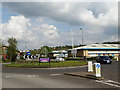
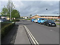
Bradmarsh Business Park, Rotherham
Sometimes referred to as Templebrook Enterprise Park
Image: © Neil Theasby
Taken: 24 Apr 2014
0.05 miles
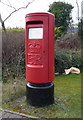
4
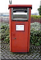
Elizabeth II postbox on Broadmarsh Way, Rotherham
Image: © JThomas
Taken: 12 Mar 2016
0.08 miles
5
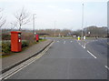
Broadmarsh Way, Rotherham
Showing position of Postbox No. S60 23 and Postbox No. S60 291.
See Image] for postbox No. S60 23.
See Image] for postbox No. S60 291.
Image: © JThomas
Taken: 12 Mar 2016
0.08 miles
6
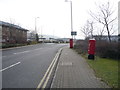
Broadmarsh Way, Rotherham
Showing position of Postbox No. S60 23 and Postbox No. S60 291.
See Image] for postbox No. S60 23.
See Image] for postbox No. S60 291.
Image: © JThomas
Taken: 12 Mar 2016
0.09 miles
7
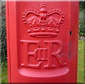
Cypher, Elizabeth II postbox on Broadmarsh Way, Rotherham
Postbox No. S60 23.
See Image] for postbox.
Image: © JThomas
Taken: 12 Mar 2016
0.09 miles
8
Elizabeth II postbox on Broadmarsh Way, Rotherham
Image: © JThomas
Taken: 12 Mar 2016
0.09 miles
10
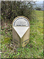
Modern Milestone, A6178
Sheffield Road. near the bus stop
Sheffield 6 / Miles // Rotherham / 1 mile
Milestone Society National ID: YS_XSFRM06
Image: © Caroline Brash
Taken: 8 Apr 2021
0.10 miles