IMAGES TAKEN NEAR TO
Foxglove Road, SHEFFIELD, S5 6FP
Introduction
This page details the photographs taken nearby to Foxglove Road, S5 6FP by members of the Geograph project.
The Geograph project started in 2005 with the aim of publishing, organising and preserving representative images for every square kilometre of Great Britain, Ireland and the Isle of Man.

There are currently over 7.5m images from over14,400 individuals and you can help contribute to the project by visiting https://www.geograph.org.uk
Image Map (Loading...)


Getting Data...Please wait
Leaflet Map data © OpenStreetMap
Images are licensed for reuse under creativecommons.org/licenses/by-sa/2.0
Notes
- Clicking on the map will re-center to the selected point.
- The higher the marker number, the further away the image location is from the centre of the postcode.
Image Listing (17 Images Found)
Images are licensed for reuse under creativecommons.org/licenses/by-sa/2.0
Image
Details
Distance
1
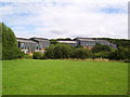
Mural at Hinde House School
See Image for another artwork.
Image: © Martin Speck
Taken: 1 Aug 2010
0.08 miles
2
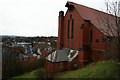
The south end of St Hilda's
For a fuller shot see Image
Image: © David Lally
Taken: 2 Jan 2010
0.12 miles
3
St Hilda's, Windmill Lane
Now abandoned Anglican Church. The building utilised the steep hill on which it stands well. The top-floor, level with the road, was the church, while the basement floor beneath housed the vestry and church hall. I only know this because I used to attend a badminton club in the hall.
Image: © David Lally
Taken: 2 Jan 2010
0.13 miles
4
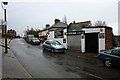
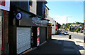
Tiny car repair shop on Windmill Lane
Presumably the message on the shutter is quite recent.
Image: © David Lally
Taken: 2 Jan 2010
0.15 miles
5
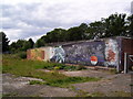
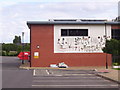
Mural behind the garages at Clover Gardens
For more street art see Image
Image: © Martin Speck
Taken: 1 Aug 2010
0.17 miles
6
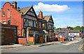
The Wharncliffe
Very large estate pub on Bervercotes Road. Now displaying Greene King livery, formerly a Stones tied-house.
Image: © David Lally
Taken: 15 Jul 2012
0.19 miles
7
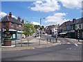
Bellhouse Road from Firth Park roundabout
Image: © Martin Speck
Taken: 14 Jun 2009
0.21 miles
8

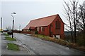
Disused Community Club on Shiregreen Lane
The former Steel City Community Club and forecourt located opposite Concord Leisure Centre.
Image: © Jonathan Clitheroe
Taken: 13 Dec 2011
0.21 miles
9
Rhythm & Booze
Off licence on Bellhouse Road.
When I was a child this consisted a double-fronted shop (the bays on the first storey extended down to ground level. Called Kenyons the side nearest was a tobacconist (which I did not frequent), the far side was a Hornby and Airfix model shop (which I did).
Image: © David Lally
Taken: 15 Jul 2012
0.23 miles